


The Integrated Geospatial Data-sharing Interface (GDI) is a standardized platform within the geospatial sector that integrates diverse sources of spatial data, tools, and services into a cohesive and accessible interface. It aims to streamline access to geospatial information, promote interoperability across different systems, and facilitate seamless data sharing and analysis. By providing a unified access point, GDI enhances efficiency in geospatial data utilization, supports innovation in applications and services, and ensures consistency in data standards and protocols for users across various domains and industries.
Additionally, establishment of a National Geospatial Data Registry (NGDR) streamlines data discovery. A rich metadata content enhances the utility of the NGDR.


Geospatial data analysis based on advanced machine learning techniques can help solve complex problems in multiple domains and help achieve the Sustainable Development Goals (SDG). Thus far there has been a challenge that stems from the lack of availability, non-interoperability and non-standard data formats that deterred from realising these benefits.
This has been recognised by the National Geospatial Policy 2022 which envisages efficient access to the fundamental geospatial data available with various stakeholders in the country. It further recognizes the need for an Integrated Geospatial Data-sharing Interface (GDI) to enable access to the datasets through universally accepted and standardised protocols. GDI addresses this gap and provides a critical digital public infrastructure to readily access geospatial data through controlled access mechanisms. At GDI, we are innovatively transforming the geospatial data landscape. We provide easy access to diverse geospatial data from both public and private sources. The advanced Spatial Data Analytics Engine serves analytics ready data allowing rapid application development.
This has been recognised by the National Geospatial Policy 2022 which envisages efficient access to the fundamental geospatial data available with various stakeholders in the country. It further recognizes the need for a Unified Geospatial Interface (UGI) to enable access to the datasets through universally accepted and standardised protocols. UGI-X addresses this gap and provides a critical digital public infrastructure to readily access geospatial data through controlled access mechanisms. At UGI-X, we are innovatively transforming the geospatial data landscape. We provide easy access to diverse geospatial data from both public and private sources. The advanced Spatial Data Analytics Engine serves analytics ready data allowing rapid application development.
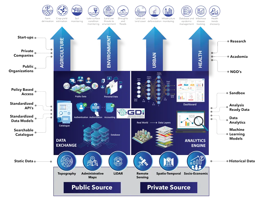
Forest fire prediction and rescue
Storm Response
Disease and epidemic management
Lake surface condition monitoring
Land use threats to environment
Droughts and Floods
Land use land cover
Urban deforestation
Infrastructure Monitoring
Farm delineation
Crop yield estimation
Soil Monitoring
Venue: Faculty Hall, Main Building
Time: 15:15 pm
 |
Shri S S Rajasekhar | Head Applications at Regional Remote Sensing Centres, NRSC / ISRO. |
 |
Shri Pankaj Mishra | Deputy Surveyor General, NIGST, SOI, Hyderabad |
 |
Shri Sanjeev Jha | Lead Architect – Government, AWS |
 |
Shri Sumit Sen | Chief Executive of the GISE Hub at IIT Bombay |
 |
Shri Prateep Basu | Co-Founder and CEO, SatSure |
 |
Prof PP Majumdar | Professor. Department of Civil Engineering, IISc Bengaluru |
 |
Dr Abhay Sharma | CTO, IUDX |
Venue: Faculty Hall, Main Building
Time: 14:15 pm
 |
Ms Ramadevi Lanka | Director, Emerging Technologies, ITE&C Department, Govt.of Telangana |
 |
Shri Naveen Kumar V | Founder of NaPanta®| Serial Entrepreneur | Digital Expert in Agri Ecosystem | REX Karmaveer Global Fellow | SLPian | tagged as Social Business Torch Bearer for India |
 |
Shri Timmana Gouda | Founder CEO, WhatsLoan |
 |
Shri Vineet Singh | Building impactful products at Digital Green |
 |
Shri Nipun Mehrotra (moderator) | Co-Founder & CEO, The Agri Collaboratory, Co-creating Digital Public Goods for Agriculture – in Open Source with the Ecosystem & Government |
Venue: Faculty Hall, Main Building
Time: 12 pm
 |
Shri Mathew Chacko | Partner, Spice Route Legal |
 |
Shri Parminder Jeet Singh | Independent Digital Researcher |
 |
Ms Saranya Gopinath | Director, Government Affairs & Public Policy at Razorpay |
 |
Ms Ramadevi Lanka | Director, Emerging Technologies, ITE&C Department, Govt.of Telangana |
 |
Shri Amlan Mohanty | Independent Technology Lawyer & Policy Advisor |
 |
Shri Rahul Matthan | Partner, Trilegal |
 |
Ms Anjula Gurtoo (Moderator) | Professor – Department of Management Studies Chairperson – Centre for Society and Policy Indian Institute of Science |
Venue: Faculty Hall, Main Building
Time: 11 am
 |
Shri Narayan Mishra | CTO & Co-Founder at TUMMOC |
 |
Shri Anucheth, M N | Joint Commissioner of Police, Traffic, Bengaluru City |
 |
Dr Sanjay Kolte | CEO, Pune Smart City Development Corporation Limited |
 |
Shri Rajesh Krishnan | Chief Executive Officer, ITS Planners and Engineers Private Limited |
 |
Shri Munish Moudgil | Special Commissioner (Revenue) BBMP |
 |
Shri Suresh Kumar (moderator) | VP & Head – Platform Deployments & Applications, IUDX |