In an era where climate change is bringing more erratic weather patterns, the consequences of heavy rainfall and flooding on agriculture can be devastating. Farmers, particularly those reliant on seasonal crops, are often left in precarious situations, struggling to recover from lost yields. In the early September of 2024, in NTR district of Andhra Pradesh, this harsh reality recently came to life when heavy rainfall led to widespread flooding, submerging vast stretches of cropland. In a significant study, the geospatial team from NIRUTHI harnessed advanced satellite data to map and assess the extent of flood damage. By leveraging Sentinel-1 SAR satellite imagery and processing it using Google Earth Engine, the researchers were able to identify the exact regions of cropland that were inundated, offering a powerful example of how geospatial data can revolutionise disaster response and aid in the crop insurance process.
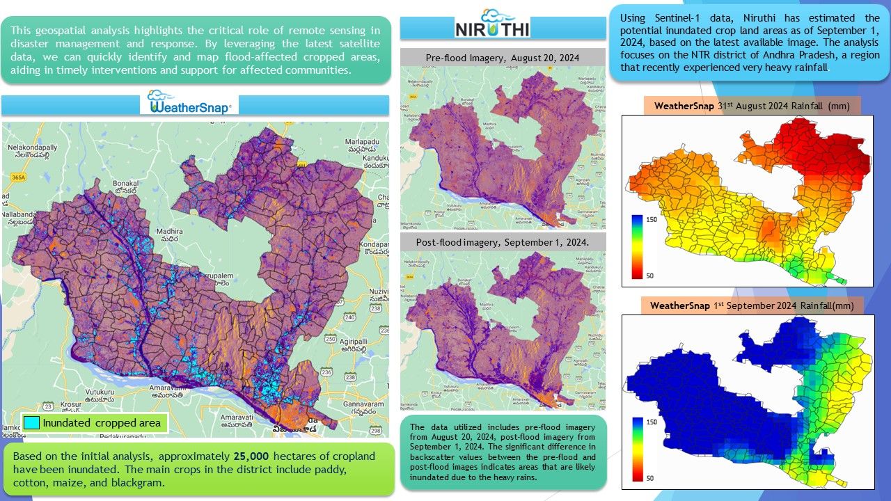
In the event of flood where cloud cover is dense, optical satellite imagery is often ineffective; radar data, however, can capture detailed information regardless of weather conditions. Hence for this study, Sentinel 1 SAR data was collected for pre-flood date on August 20, 2024 and post-flood images were taken on September 1, 2024, just days after heavy rainfall inundated the region. Other data used were – District village boundary shapefile provided the geographic boundaries needed for spatial analysis and the ESA WorldCover dataset was used to mask non-agricultural areas. WeatherSnap’s precipitation data, available on the GDI platform was also incorporated, to assess rainfall levels both before and after the flood event. This precipitation data provided indisputable proof that the flooding was caused by heavy rainfall, confirming that it was a natural disaster rather than the result of any other factor.
Using Google Earth Engine, Sentinel-1 SAR data was processed to compare backscatter values in pre- and post-flood imagery to identify inundated areas. To ensure that only cropland was analysed, non-agricultural areas were masked out using the ESA WorldCover dataset. This combination of data and cloud-based processing allowed the team to quickly and accurately identify the extent of the damage caused by the flooding. The findings of the study were alarming: approximately 25,000 hectares of cropland in the NTR district had been submerged. The region, which is known for cultivating a variety of crops including paddy, cotton, maize, and blackgram, faced significant losses. The flood damage was not just a blow to individual livelihoods but also posed a broader threat to food security and the local economy.
One of the most transformative aspects of the geospatial application is the potential to expedite the crop insurance process. Geospatial data offers a clear and verifiable view of the extent of the damage. Insurance companies can use this data to assess crop loss without the need for lengthy field inspections, speeding up the payout process. For farmers, this means that instead of waiting for weeks, they can receive their insurance payments in days, allowing them to rebuild their livelihoods more quickly. The transparency that comes with using satellite data also ensures that assessments are fair, reducing the likelihood of disputes between farmers and insurance companies over the extent of the damage. The integration of WeatherSnap’s precipitation data further strengthens this process by offering a clear proof of the cause of the flood. This not only helps in disaster attribution but also provides a concrete basis for insurance claims.
The impactful use case demonstrates how geospatial technology can fundamentally change disaster response and mitigation. Also, GDI plays a critical role in disaster management by providing the necessary data to assess damage and strengthen preparedness, ensuring communities are better equipped to handle the impacts of natural disasters. Beyond accelerating insurance payouts, using satellite data to map and monitor flood damage enables better resource allocation and disaster preparedness. For climate-vulnerable agricultural communities, this technology is a lifeline, helping them recover quickly and build resilience. As more regions embrace this technology, the process of assessing crop damage, filing insurance claims, and receiving payouts will become faster, fairer, and more transparent—offering farmers a fighting chance in an unpredictable world.
Related Posts


